sticks and seas
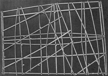
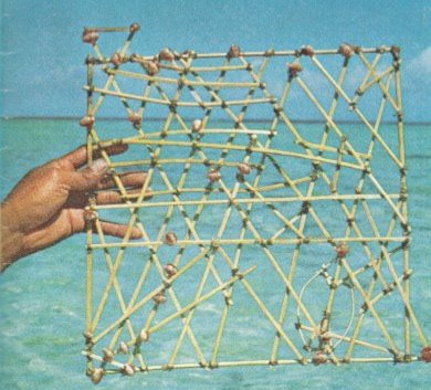

a few years ago, while visiting to hawaii, i dragged my grandmother to a small history museum because i wanted to see a "stick chart". the museum was quite special in that it seemed more like a temporary exhibit set up by a small history club than the MUSEUM listed in the guidebook. it was basically a small partitioned off area in the rear corner of an old church, and fortunately amongst the dust and handmade displays was a small stick chart. just a few strands of palm leaf bound together in a kind of square web like a simpler version of an airline route diagram. part map and part richard tuttle or al taylor ... it was wonderful; and the simplicity of materials and complexity of thought was humbling. i've never seen another one in person, but here's some info from various places the web...
in the late 1880's, while touring "the pearls of the pacific", robert louis stevenson was presented with a "stick chart" by the great kind kabua of the marshall islands. the stick chart is now in the collection of the university museum of the university of pennsylvania. marshallese navigators were famous of their knowledge of the sea, and used these unique stick charts as maps of the ocean currents among the islands.
islanders construct these maps from pieces of the narrow center rib of a palm leaf tied together with coconut fiber. grids are thus formed in distorted geometric patterns, depicting the curve, refraction, and intersection of wave patterns caused by prevailing winds. shells tied to the frame to represent the location of islands. these stick charts are not charts in the western sense but are instructional and mnemonic devices concerned with swell patterns.
there are three types of stick charts. the 'mattang' are individual charts constructed by a navigator to suit his own particular requirements. an entirely competent navigator cannot, under any circumstances, interpret a chart which he himself has not made. the second form of chart, the 'meddo' is an extension of the mattang chart in that it shows swell patterns in relation to a number of islands. the function of the meddo is to indicate the position of islands relative to observable swell phenomena, the true distances and directions between the islands being of only secondary importance. the final type of stick chart is the 'rebbilib' which covers the whole or a large part of the archipelago and is basically concerned more with islands than with swells.
0 Comments:
Post a Comment
<< Home